Workers & Resources: Soviet Republic

Workers & Resources: Soviet Republic

80 ratings
How to create maps
By Moasl
This guide is for creating maps.
There are several sections for quick reference for tips, tricks and inspiration.

currently under construction :)
2
3
   
Award
Favorite
Favorited
Unfavorite
Preface
Hello friends and comrades!

There are many ways to create maps. There are also other ways to get height maps for the game. I would like to show you how I do it.
English is not my main language. There are German words in the background of the screenshots, I hope that's not so bad :)
The real landscape photos are from my surroundings
A few inspirations are also included :)

Very important.
Good music should not be missing when creating a map!

Maybe this guide can help you
Maybe not, I don't know :D
But in any case
Even in hard times

Don't forget to smile :D
Start with a blank map
Heightmap: From where? Useful Links!
Here are some links for heightmaps generator:

First of all, there are two differences between the two height map generators.
With the CS generator, you have a square from the beginning, which illustrates the map size.
Unfortunately, this is not the case with Tangram. You have to find out by trial and error what fits best, or you later cut the downloaded height map from a rectangle to a square.
Both are pretty good and I can only recommend them.


I would like to explain the Cities Skylines Map Generator and Tangram-Heightmapper to you in a few steps

CS Map Generator
Step 1:
    You start with the "Outdoors" view and can easily switch to "Satellite" in the map views.Pick a nice location!

Step 2:
  • In the settings, the default value for the map size is 17.28 km (Cities Skylines optimal size).
  • Realistic size for WRSR is 20 km!
Step 3:
  • You have entered the map size and selected the location. Follow the next steps as shown in the picture (lower left photo).
  • There you will see "Base Level" and a calculator symbol. Click on the upper calculator first! (Marked with a green 1 in the picture)
    Then you should see a new base level there.
    Click on the "Height scale" calculator (Marked with a blue 2 in the picture), then the map is ready for export.

    Step 4:
      • As in the picture (bottom right picture), on the left side there are several ways to download your map. I always use the "Download PNG height map" (Black & White)
        You can also download the map with colour! (on the image the yellow framed symbol)
      Now you should have the height map in your download folder!
Tangram-Heightmapper


I would like to show you in a few steps. How you can export height maps with the Tangram Heightmapper

There are a few more boxes that I would like to explain briefly.

When you open Tangram you start like in the following picture.

The box with "auto-exposure" is selected.

As far as I know, Tangram only has this black and white view. You can't see that much. This has to do with the different heights.

You can help yourself by activating the "map lines". Or depending on the setting of the minimum and maximum height, you can see the whole thing much better.


Find a nice place for your map and test what the best height settings are for you.
Try downloading several elevation maps of the same location. Either use the "auto-exposure" or
set the heights yourself, as in the third picture in this chapter.


You can also select different render levels for even more detail, or just export the whole thing as it is.
Insert the Heightmap and get started?


Before we add the map to the game, we need to change something important!
  • Click on the downloaded heightmap.
  • You have to flip the heightmap 1x vertically !!! (Otherwise it will happen like in the following picture).
  • Add a blur to the png heightmap image. This will smooth out the terrain in advance.
  • Always try to save the heightmap as .PNG file


Once we have done that we can start the game!
Step 1:
  • Click on Workshop in the main menu
  • Open map editor and create new map
Step 2:
  • Proceed as shown in the following picture!
  • Click on "Terrain"
  • Then click on "Load external heightmap (.PNG)"
  • Insert your elevation map


Step 3:
  • Initially start with 1000m (maximum altitude) and -60m (depth).
  • In most cases, it looks like the following picture at the beginning!
    [Just try out a few methods! Small tip: If you have a similar situation as I have in the picture, then set the maximum depth to -20m and just try bit by bit, in relation to the maximum height, to find a nice balance!


Now we have our heightmap in place and we can get to work on the terrain editing!
Terrain-Views
There are different terrain views in the game and there is another view in the map editor.
As far as I know, the texture view is only available under terrain editing. The other views can easily be activated with the following keys, or in the right corner above your map. There 3 boxes where you can select the different views.
  • Wireframe view F1
  • Topographic view F2
  • Underground view F3
  • Texture view
And like in the following picture, if you hide the textures. This is very helpful when smoothing the terrain and generally a nice view when creating terrain.
As you can see, you can also see much further in this view.

Limit button
A few useful tips:
  • The Limit button, as the name suggests, serves as a limit.
  • With any height values, e.g. set limit to 300m and create a mountain. The mountain will be not higher than 300m! (useful to bring large areas to one height) Terrain tool "Level out from the middle" has almost the same properties.
  • Limit at resources in % (coal, iron,oil,...) Recommended!
Terrain management
I'll show you a few tips and tricks about editing terrain:
  • Designing mountains and improving existing ones
  • Helpful settings for the terrain tools
  • Smoothing terrain is important!


Let's start with the mountains!
Switch back and forth between the 3 different views when editing terrain.
I can only recommend this!

For terrain editing I recommend 2 options: either the textures on off and the topographics on, or all off! I can recommend the wireframe model in combination with the topographic view!
Try it out!

Step 1:

This example is about an existing mountain, which I will raise in the first step using the "Raise Terrain" tool. (start with the lowest picture)
  • The brush has 3 properties: The Size, Outer Strength and the Brush Strength
    If the size and the outer thickness are the same and you press on a free surface. You will get a cylindrical shape, with very rough edges/clips.
  • If Size is less than outer strength and you try the same on another surface, you will get a hill.
As you can see in the picture, I only take about 9% to lift.


Step 2:
In this step I'll show you another very helpful tool that we can use to make the mountains look even more realistic. This is good for shaping terraces in landscapes (flat fields on the mountainside, large flat areas).
After we have lifted the mountain with the help of the "Lift terrain" tool we continue with how to make the mountain even more beautiful!
  • We take another terrain tool (as shown in the following picture).
    The so called "Raise/Leve to the same height, or from the middle out-flatten tool".
  • Select the tool and take Brush Strength for these purposes 3-5% at most!
  • Proceed as in the picture! Go to the top of the mountain, press and hold the left mouse button.
  • Drag the mouse downwards in a slow movement.
  • The height at which you start with this brush tool is always the final height where the brush ends!
Try it out!


Smoothing the terrain

Step 3:
Let's move on! Select the terrain tool as in the following image.
  • When smoothing mountains I recommend the brush strength between 1-10%
  • When smoothing hills no more than 50%
  • Personal tip! smooth the whole map after you have imported the heightmap and set it to the right elevation! (best with 20-30% but watch out for the mountains! Don't hold it too long! Otherwise you will have double the work by having to turn hills into mountains again).


Best to try all terrain tools with different settings!
  • You can also automatically generate your map terrain!
  • But if you really want realistic conditions. Do it with an heightmap.
    That makes the whole thing a lot easier!


Water Erosion tools


Water Erosion tools:

As mentioned in the picture, there are the two erosion tools.
In a short time you can create a hilly landscape into a mountainous landscape.

In the settings of these tools you can define the angle of erosion. Depending on whether the erosion angle is set flat or steep, you get different shapes.

For example, as in the following pictures


Rocks and stones


>>>Very Important<<<
You can have the stones drawn automatically or by hand.
It depends on how you want to do it. However, one has to keep in mind. Once you have started drawing by hand, you should no longer press the "Generate stones automatically" button. Because in the automatic generation all stones are drawn on the set angle and disappear if there are no angles.
Resources (Coal, Iron,...)
When it comes to resources, I would like to keep it rather short and sweet.
  • With the resources, it's a matter of taste. How many resources? and at which locations should they be? Decide for yourself!
  • I can only give you one tip. As I mentioned earlier, there is the Limit button and with it you can regulate how much you want to have at most!
    Personal tip when painting resources: set a maximum of 80% when setting the limit.
Everything about water (mountain lakes, waterfalls)
You can find everything on the topic of water here below

https://steamhost.cn/steamcommunity_com/sharedfiles/filedetails/?id=2793848729
Realistic planting


In the pictures above you can see well what I mean. Trees don't always grow the same everywhere!
There are different types of plants, these differ in:
  • Deciduous trees, conifers, shrubs, perennials and grasses.
  • Height of growth, location, sun and much much more!
  • Water availability! Compared to trees, shrubs need much less water!
  • (well suited for dry areas, steppes, deserts)
  • There are mountains that are covered with forests.
  • But there are also mountains that do not offer a good habitat for trees because of bad conditions and nothing grows there. (Too strong wind!, too little soil or poor basic supply, or because there are no trees far and wide, like in parts of Iceland).

For example: The closer you are to the equator, the higher the tree line is and thus the limit for tree habitat. In the Central Alps, the limit is 2,100 m above sea level, on the South American Tierra del Fuego Islands already 300 m. In the Himalayas, on the other hand, trees can still be found up to an altitude of 4,400 m. Plants are true survival artists.
I would like to explain briefly how certain plants survive.
There are trees/shrubs that can only reproduce through certain factors. For example, a tree produces fruits which are eaten by animals and certain seeds only get a germination factor through this process and thus a new tree can grow. Or otherwise seeds are distributed by the wind. A branch breaks off and gets stuck in the ground. This can cause a new tree to grow.
There are other possibilities, but this is how our beautiful landscape types on our planet are created.
The plants adapt to the environment. Depending on what the plants need to survive.
I can only say one thing. Plants and nature are fascinating.

It always depends on which scenery you want to realise!

Landscape types:
  • Mountain landscape
  • Desert
  • Tundra
  • Taiga
  • Steppes
  • Savannahs
  • Swamps
  • Tropical regions (rainforests, islands, South America, parts of Asia)


Not all forests are created equal!

You can also have forests generated automatically, or place the trees and shrubs yourself. I prefer the latter!

There are many different types of forests. I would like to list a few:
  • Taiga (coniferous forests, pines, spruces,...common in northern zones of the earth, Siberia, Alaska, Canada, parts of Europe ...)
  • Deciduous and mixed forests (beech forests, floodplain forests,...)
  • Hardwood forests (Mediterranean zone, Italy, Greece, many islands around the Mediterranean)
  • Dry forests (very dry areas like Mexico, parts of South America, parts of India, parts of the middle east,...)
  • Tropical rainforests (Amazon, parts of South America, parts of Asia, Oceania,...)
There are so many different plants but unfortunately at the moment there are only:
  • Beech (Fagus sylvatica)
  • Spruce/pine (Pinus sylvestris, Pinus sibirica, Abies alba, Abies sibirica, Picea abies,...)
  • Poplar (makes a good avenue tree!) (Populus)
  • Acacia or Robinia (Robinia)
  • Bush/shrub

In the following pictures I would like to show you a few combinations and how you can create a forest!


Tips and tricks
  • As in the picture above, you have the option "Add trees with one click"(by the blue circle). This is very handy if you want to place trees with pinpoint accuracy!
    If you turn this off you can "paint" the longer you hold down the left mouse button the more trees/shrubs will be placed.
  • There is a brush size again
  • You can also change the number of trees when placing them at will.
  • In the top picture I worked with the brush size 75 and placed different numbers of trees.
    From left to right 10 -> 30 -> 100 -> 300 trees/shrubs
  • There are 2 options to delete the trees/shrubs. Either you remove the trees/shrubs with the brush, or you remove all trees on the whole map!
  • You can choose the trees as you like, there can be more than one and you can place different combinations!
  • Small tip! e.g. if you place a beech forest. In the settings, select not only the beech, but also the bushes/shrubs to go with it. This makes it more realistic and more beautiful at the same time! Every forest consists of several layers, grass layer,herb layer,shrub layer,tree layer.


    The following pictures show you step by step how to create a forest
    Proceed as shown in the pictures!


    I started at the red dot and kept the left mouse button pressed until I reached the blue dot. From the middle is often easier!


    It would be great if a few more trees and shrubs were added to the game, or in different variations. (For example: normal beech green in latin "fagus sylvatica", copper beech naturally red leaves in latin "fagus sylvatica purpurea").

    Then you could build nice parks for the inhabitants, with colourful planting!
    e.g. the larch (beautiful bright yellow autumn colouring)
    the well-known birch with the beautiful white bark, or flowering shrubs, there are so many.


Custom Houses
Customs house and external power connection!
  • You can find the Customs buildings and the External power connection in the CIV objects folder!.
  • In this folder you will also find other buildings, such as old city buildings,.... for your map!
  • Always place the customs buildings approximately on the centre, the white map border/line, so that there are no problems in the game!
  • It is best to place the external power connections further into the later game area so that there are no problems with the connections during the game!
  • Connect roads/rails and power lines from the white map line to the map end! (just looks nicer!)
  • Don't use overhead lines on the rails abroad!

In the following pictures you can see examples!


Ready? Publication in the workshop


From map editor to game world in a few steps
  • If you think your map is ready to play. Check your map again! (resource distribution, if the border buildings are placed correctly and so on).
  • If this is done, just click in the settings -> Save map.
  • You can now leave the map editor and go to the main menu.
  • Proceed as follows "Workshop -> Own Objects (WIP) -> click on the + at the bottom right "Create new object"
Then you should see this window


Proceed as in the picture above!
  • You have to give your map a name. Under this name your map can be found in the workshop. You can only change the name of the map in the game! This does not work in the workshop!
  • The mod object is initially set to private, from the visibility in the workshop. You can change this in-game or later in the workshop.
  • Very important! Change the mod object to Landscape.
  • You need to insert a picture for your map. Must not exceed 1 MB!
  • You must also insert a text document. (Small tip: I always insert the same text document and simply change the caption later in the workshop. There you have a better overview)
  • As soon as you have done this you can click on the blue plus.
  • Now you should see a green tick instead of the blue plus.
  • The green tick is now used to upload or update your mod object!
  • Important! Click on the green tick right away to save the settings!
Continue in the next picture


As in the image above
  • Now you can insert your saved map.
  • Click on "Import Terrain"
  • Your map will now open in map editor mode. Simply save and exit the map.
  • You are back in the Main Menu go to "Workshop -> Own Objects (WIP)". Your map should now appear there! Just click on the map again.
  • Once you have done this, very importantly, click on the green tick.
    After clicking on the green tick, the map will be uploaded to the workshop.
  • Once this is done, quit the game and go to the workshop.
  • Under your profile you should see "Own Workshop Submissions". There you can access your map, subscribe and add more pictures and descriptions.
When uploading do not forget ! ! !
From time to time there is content on the workshop where the file size does not correspond to what it should have.
For example. A map has several MB and if there is only 0.1 MB next to the map in the workshop, then the map file is missing.

When uploading do not forget!
The first time you confirm, you only create a workshop content without the terrain. As soon as this is done, you have to insert the terrain.
As soon as you have loaded the terrain, you have to confirm it again.

Once you have loaded the terrain, don't forget to click on "Save quickly" and exit the map. Now you are back in the start menu. Go straight back to the WIP menu in the game and search for your map.

You have to accept the workshop content again with the green tick.
Now you should see a few MB more in the small upload window.

Closing words


If you have any questions or additions for the guide, or there is a mistake somewhere, please leave a comment below.

Have a nice day ;)
Moasl

65 Comments
Moasl  [author] 31 Jul @ 8:36am 
Great to hear that it works with that. Thank you!

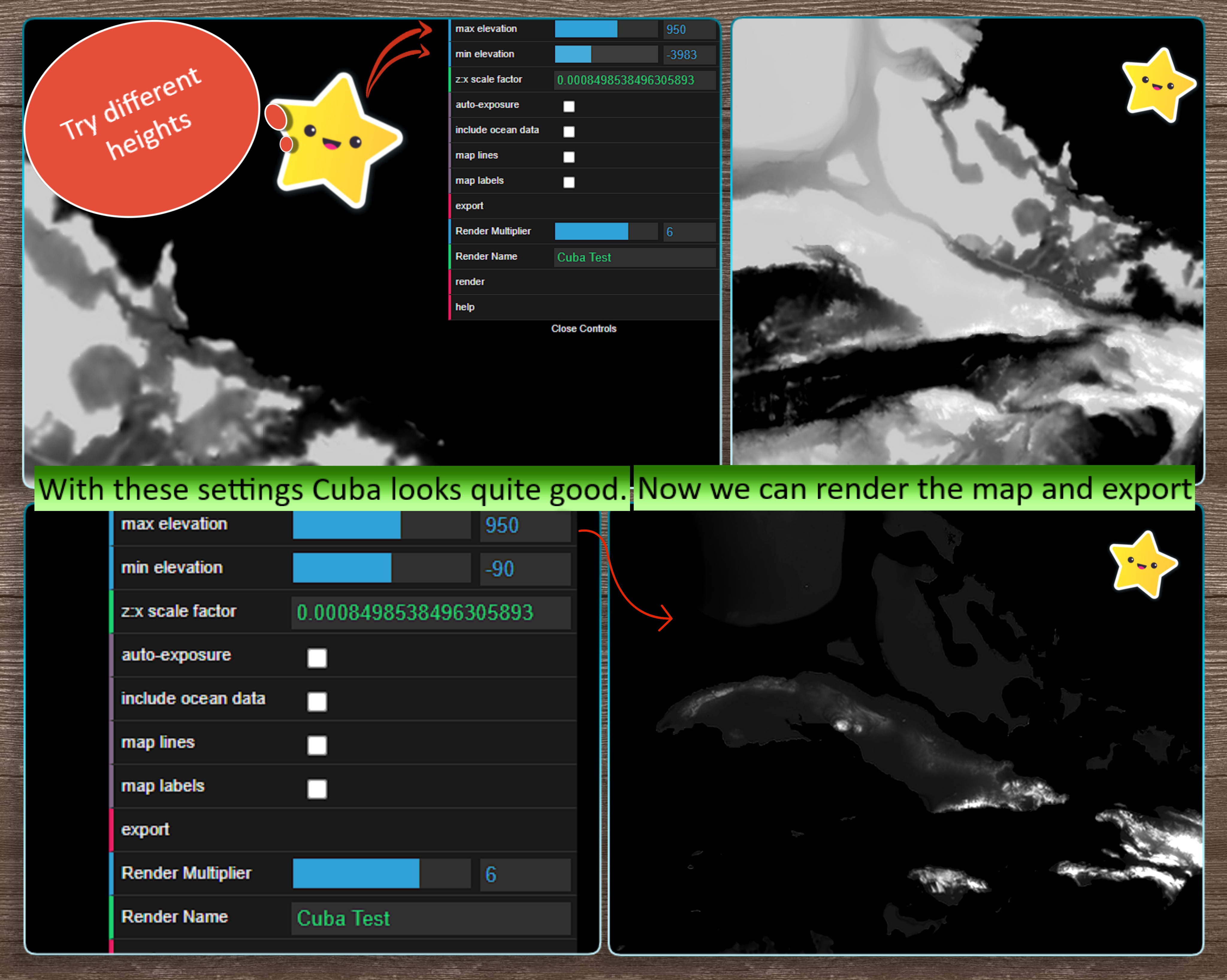
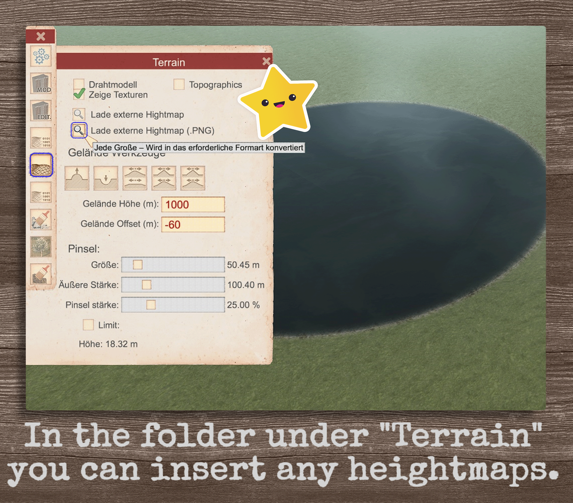
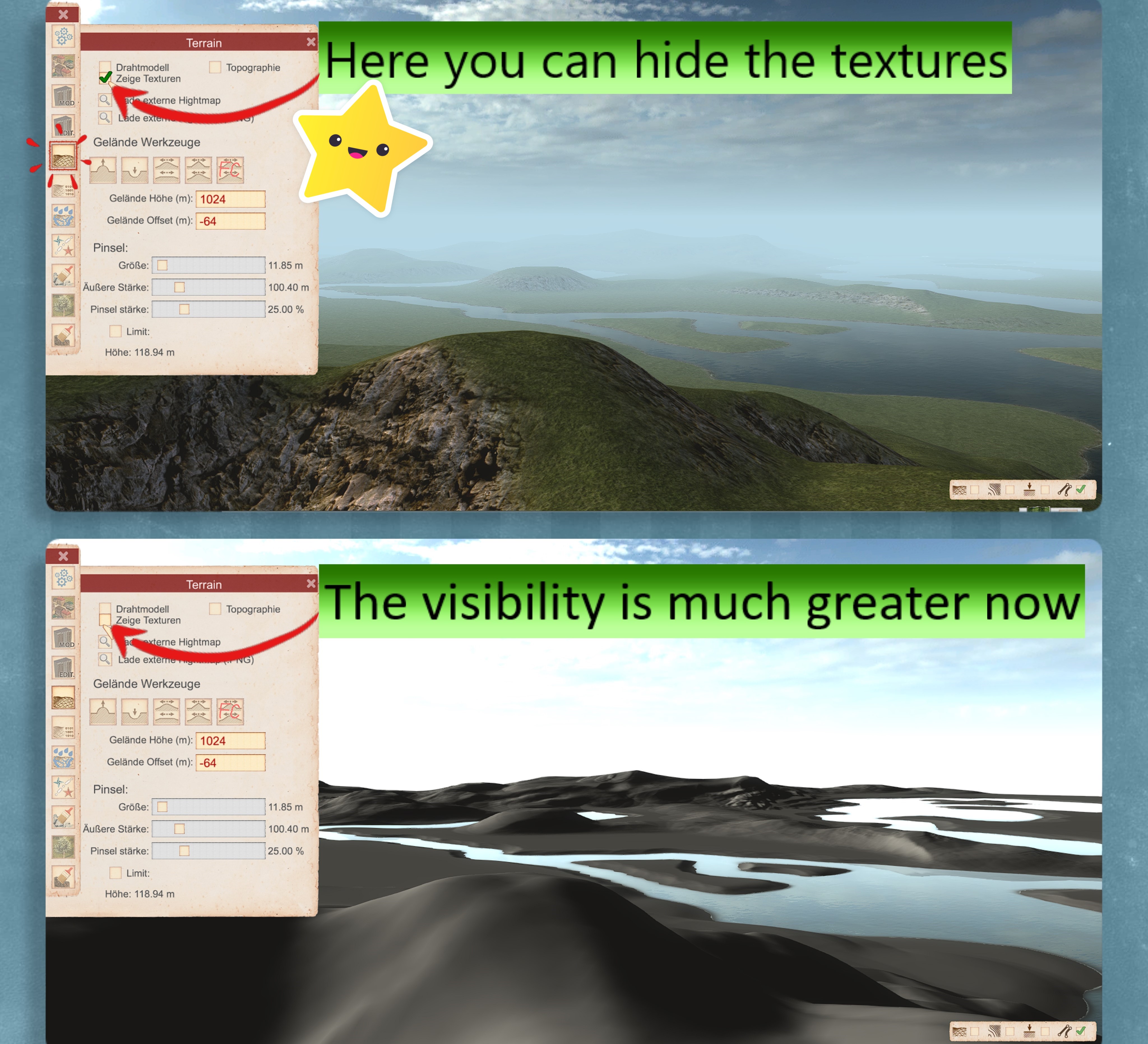
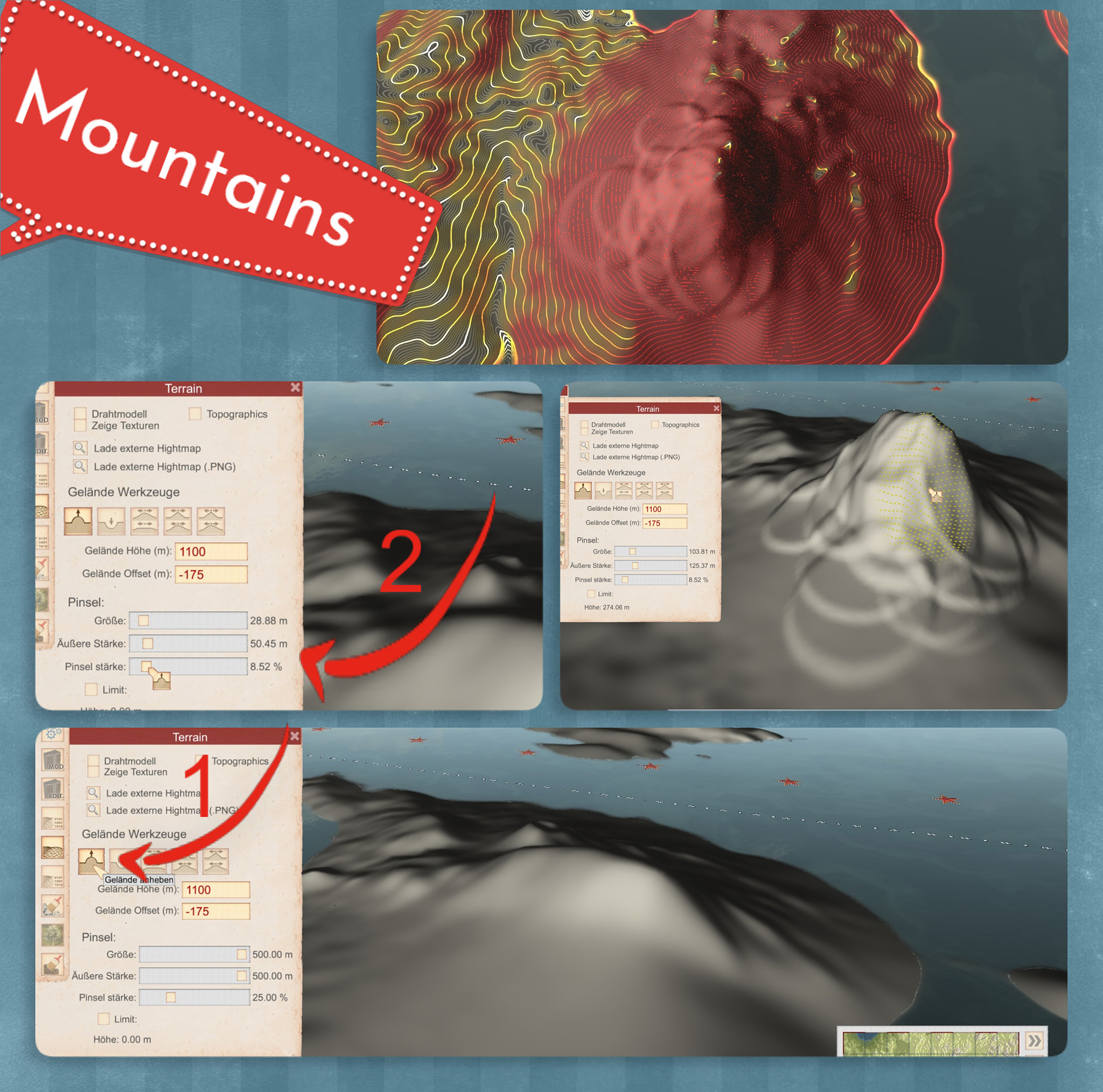
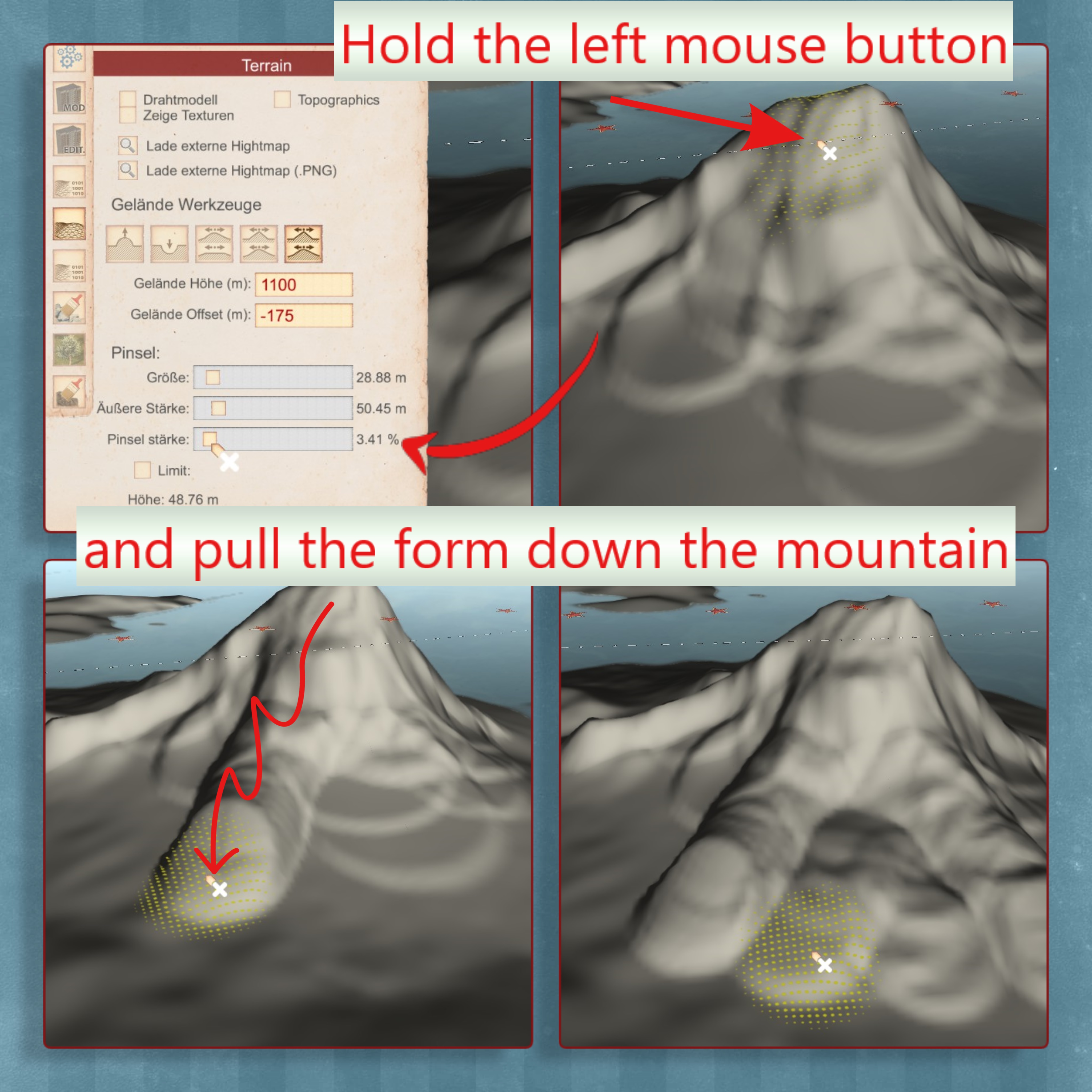
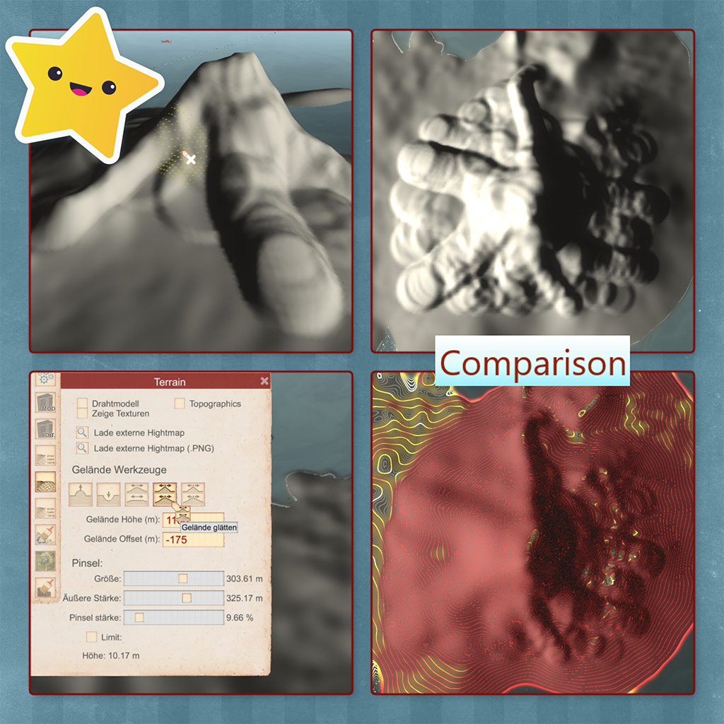
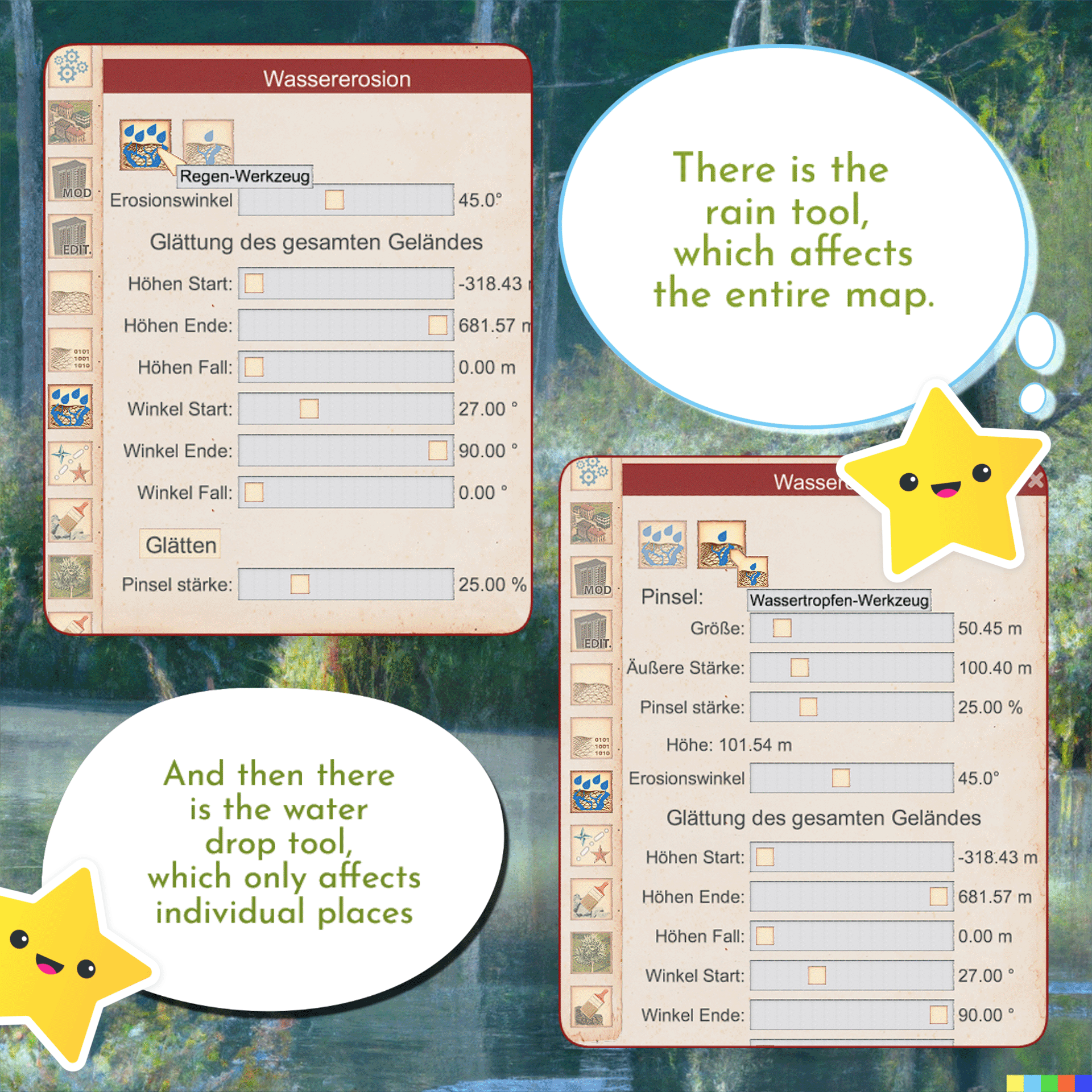
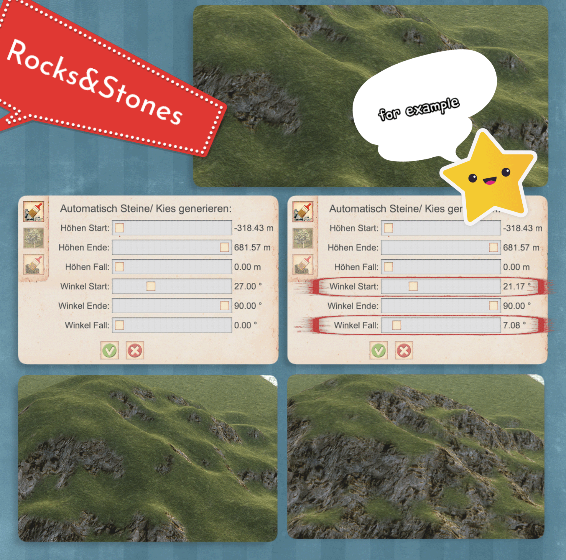
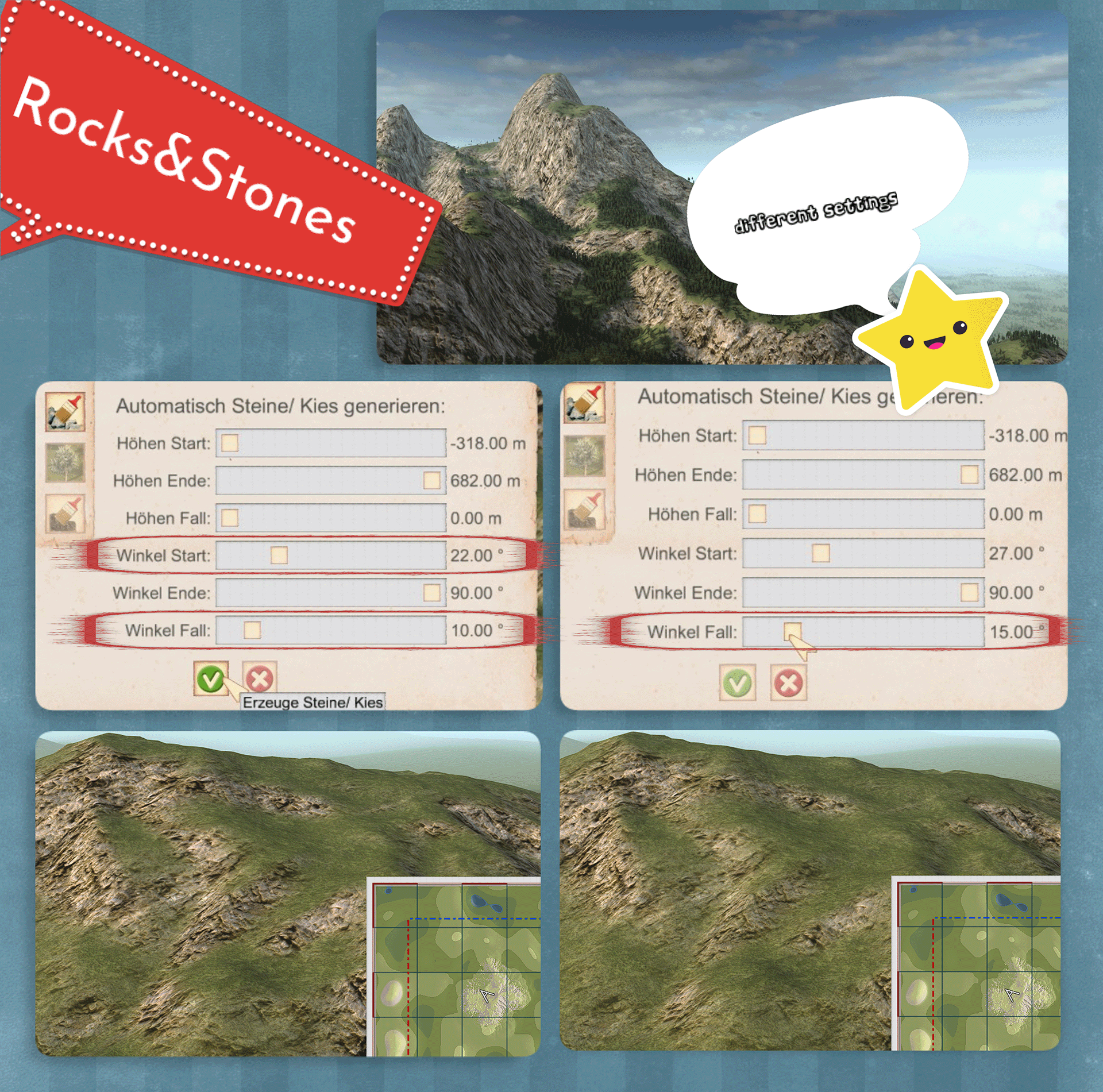
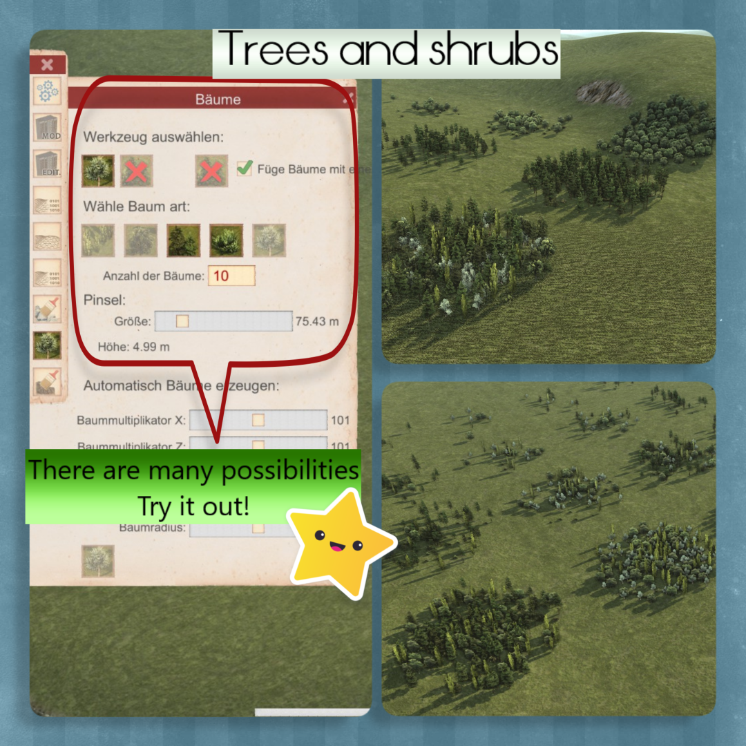
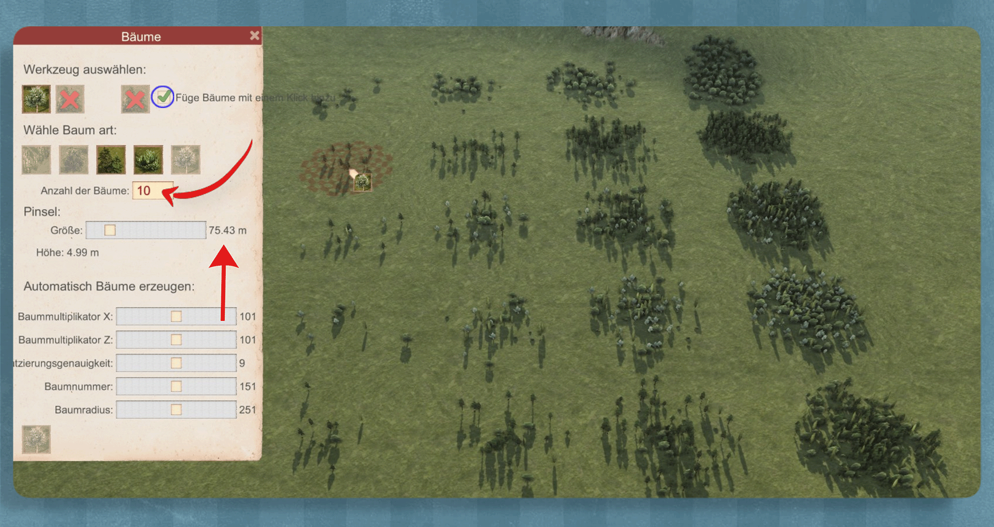
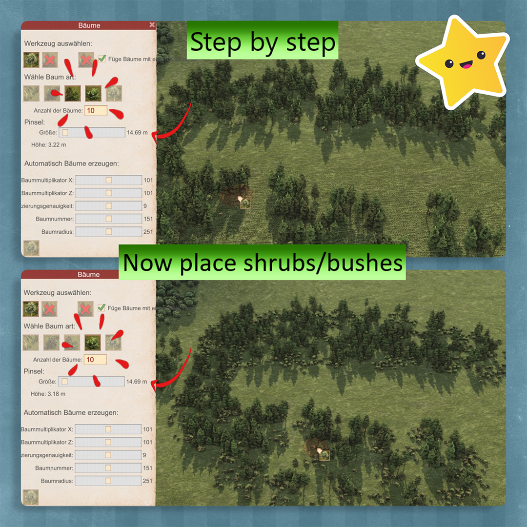
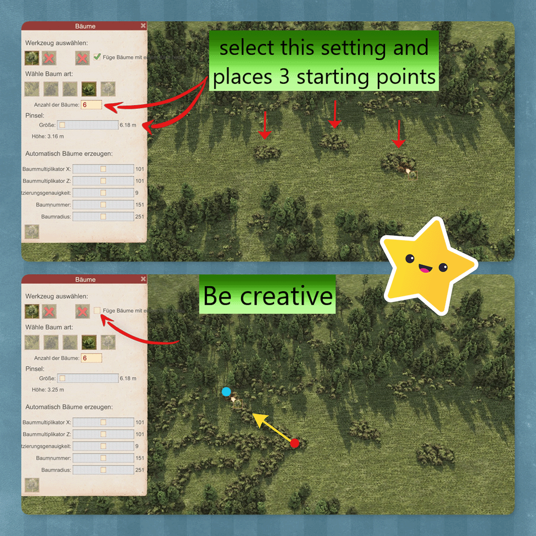
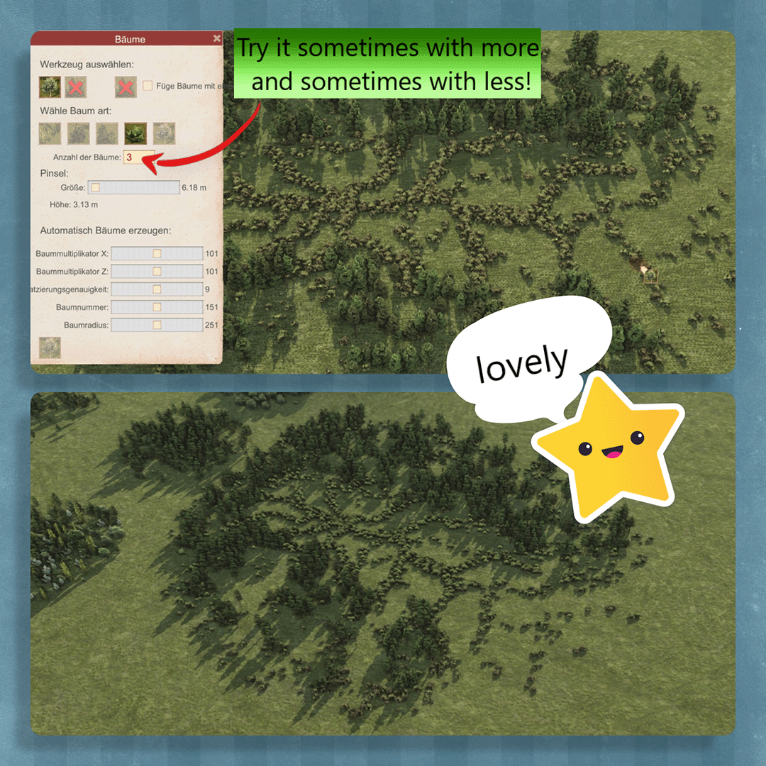
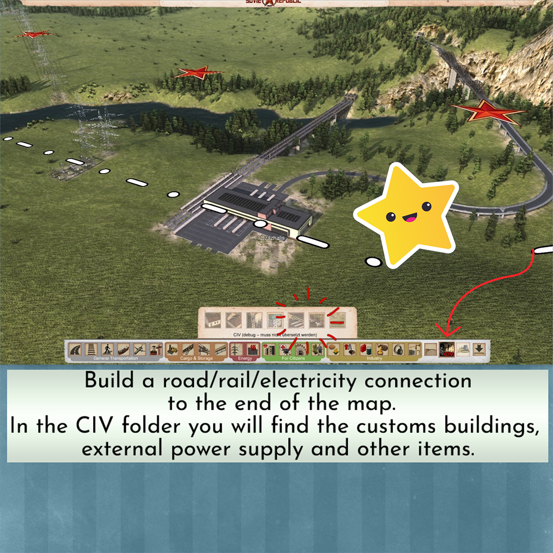
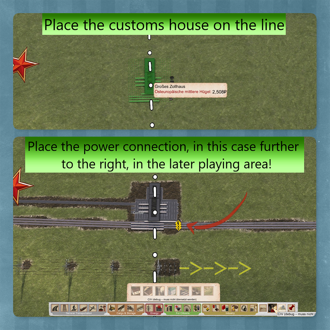
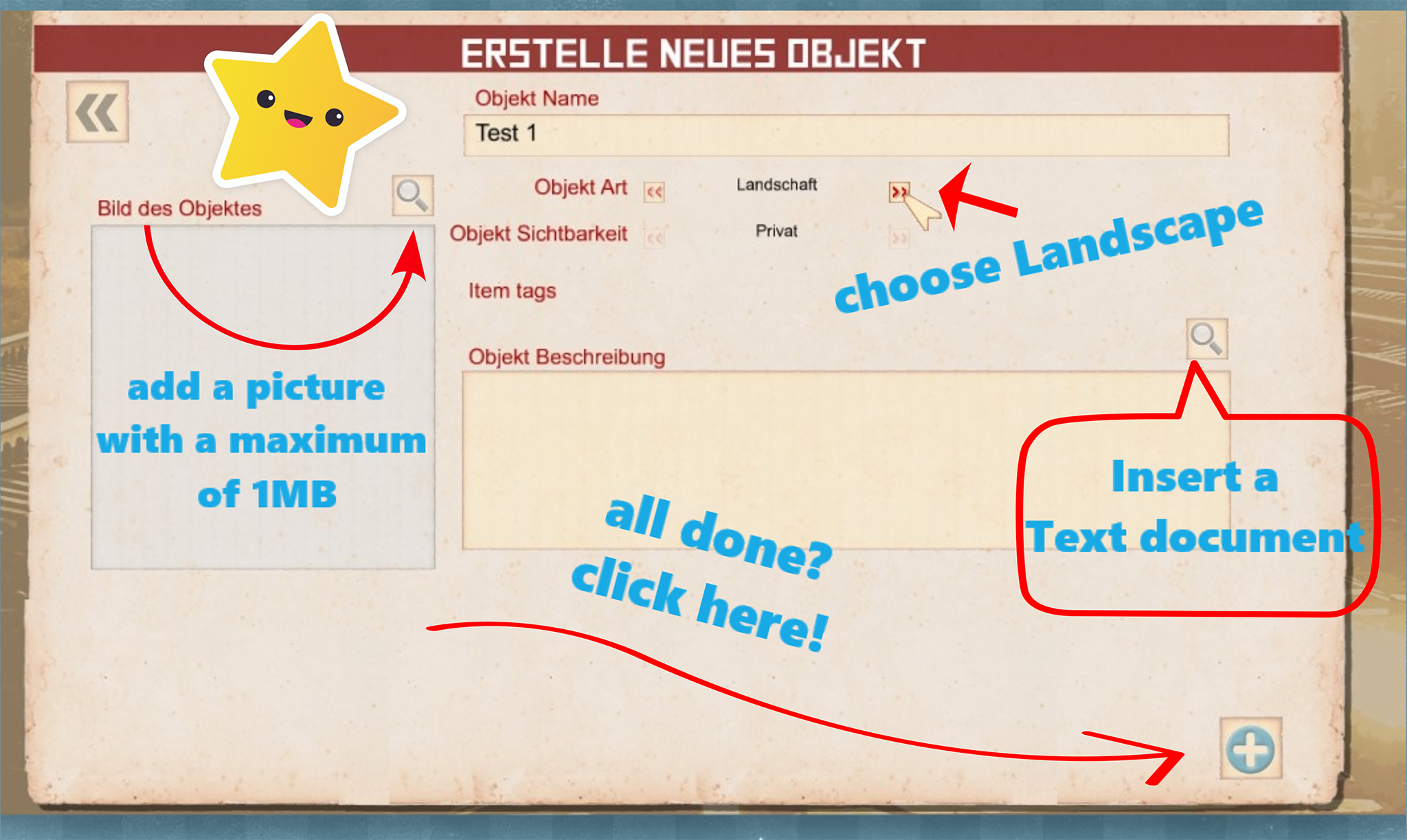
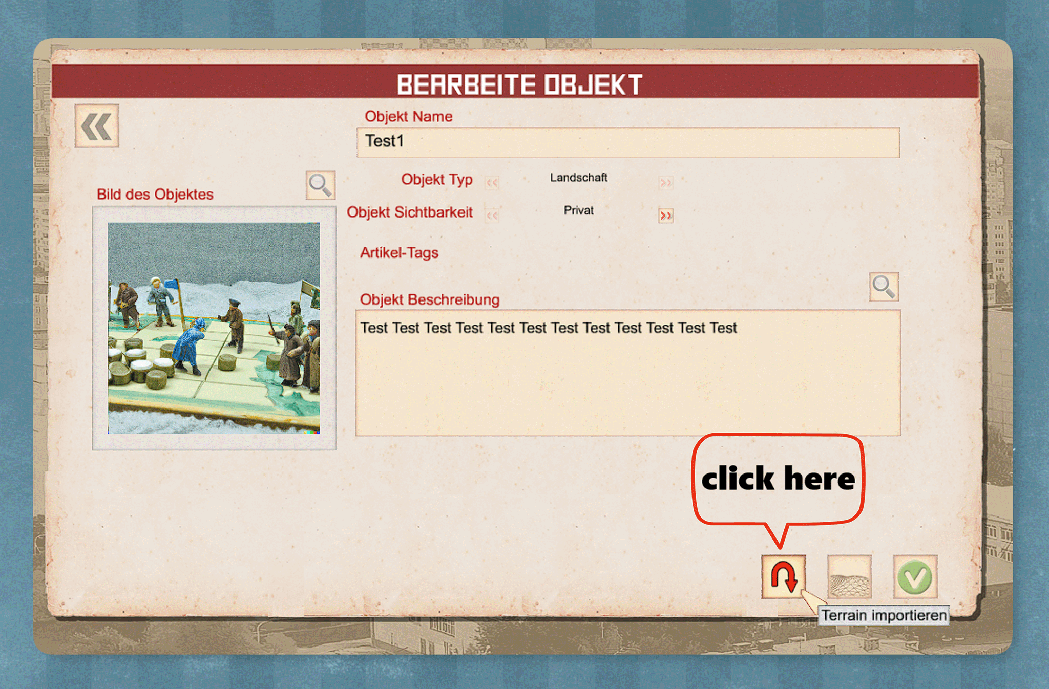
Yes it's a bit tricky and maybe I didn't explained it well in the guide but ingame tooltips would be great to have.
Sirius Czech 23 Jul @ 1:57am 
Just FYI - skylines sites are still working, the only thing required is a mapbox API key, but that is a thing obtainable for free just after a (free) email registration, so that´s what I did.

Btw the part about publish-open terrain - save again took me a while on my own. Managed, but I still have no idea why it has no tooltips or anything in game.
BWR | Alex_Sobolev 13 Jul @ 11:02am 
Thank you very much for the link to unrealheightmap for creating height maps. Until recently I could not start creating new maps because the sites I used before stopped working. And now I can start creating maps for the game again, Thank
Moasl  [author] 5 Jun @ 3:47am 
<3
Jnx "Anarxia" Sinfinity 4 Jun @ 1:45pm 
I love you
Moasl  [author] 25 May @ 8:43am 
I would use the elevation brush. Select the first circle to a small amount like 1 meter and the outer circle like 500 meter. it will take a bit but playing with it will get you nice mountains and with the erosion tool (watertool) it will be even better.
ополоченец 25 May @ 8:01am 
how do I make high mountains whitout making all territory extremely high?
Moasl  [author] 17 May @ 3:59am 
Yes, the game works fine with black&white heightmaps.
Freeman 16 May @ 7:36pm 
wait so does the game take white and black heightmaps without me having to make any color changes?
Moasl  [author] 8 Apr @ 11:40am 
You can use for example the Esri World Topo Map and if I go to a random place I click on the "Generate Heightmap" and it gives me a nice heightmap in black and white