Cities in Motion 2

Cities in Motion 2

Not enough ratings
Simulating Intercity Rail Traffic
By PeaceDaddy
In real life (IRL) cities aren't self-contained and shut off from the rest of the world. Rail traffic crosses borders, and citizens need and want to explore the world beyond their city confines.

Intercity rail traffic is a major component of a city's transit system, and the stations that serve these rail lines are economic hubs that drive and shape the development of the city as a whole.

But in CiM2 life, cities are closed off from the rest of the universe. To make more realistic cities, we need to trick CiM2 by simulating cross-border traffic.

In my guide, I'll show you some ways to do that. Read on!
   
Award
Favorite
Favorited
Unfavorite
1. Find some undeveloped land, preferably near the edge of your map.
Map Credit: Eifelsburg1.0
2. Build a rail line to this area.
Since this area is near the edge of the map, make sure you think about depots and/or turnarounds before you start to develop it.
Map Credit: Eifelsburg1.0
3. Build a self-contained disconnected neighborhood.
Now you'll build a neighborhood that is disconnected from the rest of your street network.
Map Credit: Eifelsburg1.0

This neighborhood will be centered around a train station. The idea is that all traffic in and out of this neighborhood will have to be by train. Use pedestrian streets because cars will have no access to the rest of the city. We'll call these neighborhoods "simulated cities" because they are going to take the place of real cities that lie just across the border of the map.
Map Credit: Furstenhall_v1.5


4. Place high traffic-generating buildings.
Buildings like landmarks and tourist attractions, large office buildings, and shopping facilities are preferable.

The idea is to generate as much traffic to/from your simulated city to fill up your simulated intercity trains!Map Credit: Furstenhall_v1.5


In the European buildings set, the Hypermarket is ideal. There is no limit to how many you can place and they generate a lot of traffic.

If you are more concerned with efficiency than with aesthetics, you can string lots of Hypermarkets in a row lined up along your train line.
Map Credit: Furstenhall_v1.5
5. Build a metro/train line from the simulated city to a main station.
Now you'll develop a metro line from the simulated city to your central or main station.

IRL intercity trains only stop at one central or a limited number of important stations. So have your train line go directly there.
Map Credit: Eifelsburg1.0

6. Use 4-track sections and waypoints to bypass local stations.
On its way to your main station, your simulated intercity rail line may pass through several local stations. Rebuild these with 4-track sections, and use waypoints so that your intercity trains can pass through them without stopping or being held up by local trains.
Map Credit: Furstenhall_v1.5Put the waypoints on the center tracks since stations will always be on the outside tracks.
Map Credit: Furstenhall_v1.5
Case Study I: Ediacara
For this case study, I'm using the excellent Ediacara map by skraddel.

This map includes a wonderful, sprawling modern station. But there's a problem...
Map Credit: Ediacara by skraddel


...and that is its location. It's all the way at the northeast corner in a low-density industrial area. It has no practical value as a transit hub for the city due to its remote positioning.
Map Credit: Ediacara by skraddel

There's a quaint old station...
Map Credit: Ediacara by skraddel
...right in the center of town. Perfect for a transit hub, but a totally inadequate facility for a modern city.
Map Credit: Ediacara by skraddel


It reminds me of Liege, Belgium with its extraordinary modern Guillemins station in a remote quarter and its cramped Palais station in the center of town.

But back to Ediacara, I tried several attempts to make the big modernist station on the edge of town work but could never drive traffic there. It was just a white elephant. To make the station live up to its potential, I'd have to try a new strategy.

Enter the concept of simulated inter-city trains. I added several simulated cities to the map and linked them to the modern station.Map Credit: Ediacara by skraddelMap Credit: Ediacara by skraddel
Now the main station is bustling with activity!
Map Credit: Ediacara by skraddel
Case Study II: Krakow
The Krakow map by Dortmondo is very realistic. But to make it as realistic as possible, its Glowny station, i.e. main station, must take into account passengers traveling to places like Warsaw and Katowice.

To model this, I added simulated cities.

For Warsaw, you see I have Warsaw Centralna station modeled here. But there's nothing around it. Where are all those passengers coming from?
Map Credit: Krakow by Dortmondo

IRL trains leave from Krakow Glowny station and stop at Warsaw Centralna (or vice versa). From there passengers can connect to other trains for their onward journey to places like Bialystok, Lublin, Gdansk or just to local Warsaw stations like Wschodnia or Chopin Airport.

So I basically simulate that. I have a line that takes passengers to "Warsaw Centralna" station ...
Map Credit: Krakow by Dortmondo...and from there the passengers will catch another train to their final desination.
Map Credit: Krakow by DortmondoMap Credit: Krakow by DortmondoMap Credit: Krakow by DortmondoMap Credit: Krakow by DortmondoYou'll notice I have 5 stations that represent Warsaw and 1 to represent Bialystok. This models the difference in number of travelers going to each city.


Back at Krakow Glowny station, passengers coming from any station in Warsaw or Bialystok or Lublin will arrive on the same train at Glowny station. From there, they can connect to the Krakow local transit system (still under construction) to go anywhere they need to go in Krakow.
Case Study III: Friedrichstadt
This is using the expansive Friedrichstadt map. Similar to big cities like Paris and London. Friedrichstadt doesn't have a single central station. It has 3 major stations located on the periphery of the historic central city.

From each of those 3 stations, I wanted to model suburban trains that take commuters back-and-forth to their homes in the greater area. To do this, I created cities on the map's edges that link to one of the three stations.
Map Credit: Friedrichstadt
This is the southwestern suburban train system map,...
Map Credit: Friedrichstadt
...this is the eastern station suburban train system (north is toward the right side of this map)...
Map Credit: Friedrichstadt
...and this the northern station suburban train system.
Map Credit: Friedrichstadt
4 Comments
Mvek 2 Oct, 2022 @ 9:16am 
Thx @PeaceDaddy, I have googled it here: https://www.wisim-welt.de/webfiles/index.php?entry/499-friedrichstadt-inspiriert-von-deutschen-großstädten/
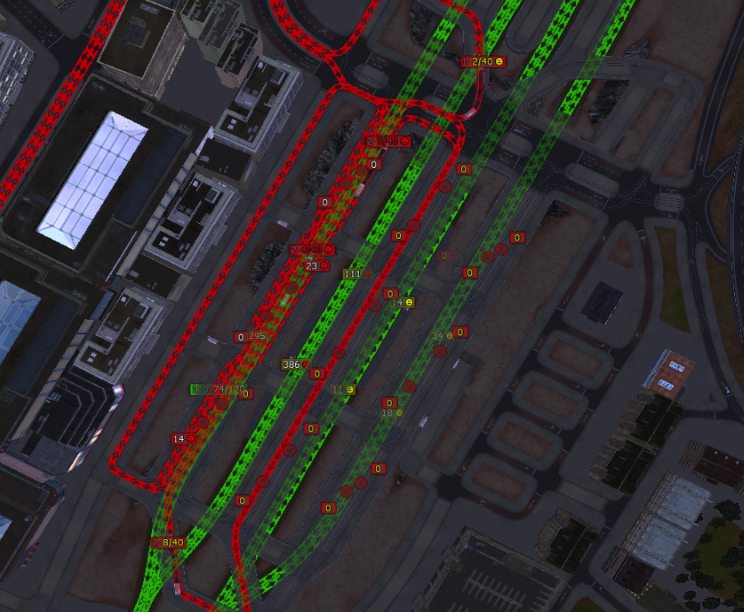
so I will try it. I am currently modifying Krakow to my liking (I like it to look interesting, realistic), which I might post later as a derived map.
PeaceDaddy  [author] 1 Oct, 2022 @ 10:04am 
Hi @Mvek. I honestly don't remember where I found the Friedrichstadt map. It doesn't look like it's here in Steam, so it must have been from the Cimexchange. :(

As far as I am concerned, it is the best map ever created for CiM2.
Mvek 21 Sep, 2022 @ 7:34am 
Is the Friedrichstadt something not anymore present on Steam, or was it downloaded from the old CiMExchange or other website?
Monsieur Bob - Empereur des Ours 27 May, 2021 @ 8:25am 
Very interesting !