Transport Fever 2

Transport Fever 2

336 ratings
Lausanne - Sion
9
12
3
4
14
8
4
3
4
2
2
   
Award
Favorite
Favorited
Unfavorite
Map/Savegame: Map
Tags: Alpine
File Size
Posted
198.318 MB
26 Jan, 2023 @ 10:16am
1 Change Note ( view )

Subscribe to download
Lausanne - Sion

Description
Lausanne – Sion / Switzerland
From the capital city of the canton of Vaud to the capital city of the canton of Valais. From Lausanne along the shore of Lake Geneva, through the towns of the Vaud Riviera and the Rhone Valley up to Sion.

One of the most beautiful regions in the world, mapped at a scale of 1:2 based on airborne laserscan data with a vertical resolution of 0.1 metres and a horizontal resolution of 10 metres.

The railway lines running in reality are imprinted on the terrain.

If you like this map, please leave a like (via the "thumbs up button").

Specifications
Scale: 1:2
Towns: 34
Map size: megalomaniac
Aspect ratio: 2:1
Start year: 1850
Level: difficult

Towns
Abondance, Aigle, Ardon, Blonay, Champéry, Évian-les-Bains, Forel, Fully, Lausanne, Le Châble, Les Diablerets, Leysin, Martigny, Monthey, Montpreveyres, Montreux, Nendaz, Ollon, Orsières, Palézieux, Port-Valais, Puidoux, Riddes, Saint-Maurice, Salvan, Sembrancher, Sion, Thonon-les-Bain, Troubois, Val-d'Illiez, Verbier, Vevey, Villars-sur-Ollon, Villeneuve.

Railway Lines
The railway lines that exist in reality are imprinted on the map as fine, narrow terrain elevations. These lines also include various narrow-gauge railways leading from towns in the valley to villages on the mountains. Using these imprinted "guidelines", the model builder can easily recreate all railway lines at the places where they exist in reality - as soon as he has earned the necessary capital. If he does not want to do this, he can easily level the terrain elevations.

Roads
The map contains the main country roads between the cities which are depicted. The route of the country roads corresponds to the route in reality (with very few exceptions).

Industries
With a few exceptions, the industries included are mapped at locations where comparable industries exist or once existed in reality. However, in order to fully cover the needs of all cities later on, an industry mod will be needed that increases the production quantities of the existing industries.

Map Extract
The map extract is chosen so that the largest cities (Lausanne, Sion, Martigny and Thonon-les-Bains) are located in the corner regions of the map and cannot usually be reached via straight connections to each other. This results in numerous long driving distances that have to be covered when supplying these cities.

Rivers
The Rhone was depicted slightly wider than in reality, so that it is navigable.

Digital Elevation Model
The digital elevation model, a section of which was used to create the heightmap, is from Sonny: https://sonny.4lima.de/. For the underlying licence, see the following excerpt, which is taken from a readme file of the height model:
"This Terrain Model is OPEN, FREE and WITHOUT CHARGE. But it is licensed using the following LICENCE: Creative Commons Attribution 4.0 (CC BY 4.0),
look at https://creativecommons.org/licenses/by/4.0/deed.en"

Map data
The position of the cities, railway lines, roads, rivers and lakes was reproduced on the basis of OpenStreetMap data (©OpenStreetMap contributors). For the underlying licence see https://www.openstreetmap.org/copyright/en.
"OpenStreetMap® is open data, licensed under the Open Data Commons Open Database License (ODbL) (see: https://opendatacommons.org/licenses/odbl/) by the OpenStreetMap Foundation (OSMF) (see: https://osmfoundation.org/)."
(https://www.openstreetmap.org/copyright/en)

Setup under version TPF 09 March 2023
  • Set up Transport Fever to support experimental map sizes. For the steps to be taken see:
    https://www.transportfever2.com/wiki/doku.php?id=gamemanual:mapsizes
  • Subscribe to this map
  • Subscribe to the mods listed on this website under "REQUIRED ITEMS"
  • Download the mod "Natural Environment Professional 2" by Grimes from the Transport Fever forum:
    https://www.transportfever.net/filebase/entry/5942-natural-environment-professional-2/
    select the latest version, as of March 11, 2023 this was the option:
    "NEP² v2.2 für die TpF2 Build 35230 oder höher (aktuell Version)"
    (if an older version of this mod is already installed, it must be uninstalled before. For the necessary steps see: https://www.transportfever.net/filebase/entry/5942-natural-environment-professional-2/)
    Unzip the downloaded file
    (As of March 11, this file is: "unixroot_natural_environment_pro_tpf2_stable_2.7z")
    Copy the folder "unixroot_natural_environment_pro_tpf2_2", which is located under the extracted files, to the following directory:
    "\Steam\userdata\<your-user-id>\1066780\local\mods\"
  • Start a free game in Transport Fever 2
  • Select the option "Play Map"
  • Select this map
  • Click on "Select options"
  • In the "Mods" tab, DESELECT the mod "Natural Environment Professional"
  • In the "Mods" tab, select the mod "Natural Environment Professional 2.2"
  • In the "Mods" tab, set up the following load order:
    1) Alpine Climate 900m
    2) Natural Environment Professional 2.2
    3) Water textures
  • In the "Advanced Settings" tab, select "ALPINE-900M" as the climate.
  • Click on "OK"
  • Click on "Start"
  • Change HUD Icon filters as you like, on this see point 1 on https://www.transportfever2.com/wiki/doku.php?id=gamemanual:userinterface#hud_icon_filter

License Conditions
©Kartografix - All rights reserved
Uploading this map to other sites is prohibited.

If you build your layout on this map, you are welcome to post pictures and videos of it in forums and on Youtube. Reviews of the map are also welcome.

Disclaimer
No liability is accepted for any damage to hardware and/or software caused by this map/modification.

Donations
If you like this map, please leave a like (via the "thumbs up button").

If you would like to support the development of further maps of this kind, I would be very happy about a donation:

[www.paypal.com]

Preview-Videos
The videos of the map are from:
Hans Dampf (https://www.youtube.com/@HansDampfYT/featured)
train gamer (https://www.youtube.com/@TrainGamerYT)
TrainLéo (https://www.youtube.com/@trainleo_)
OX-Gaming zockt (https://www.youtube.com/@OX-Gamingzockt)
maettu (https://www.youtube.com/@mattusideen7292/videos)
Maurbell (https://www.youtube.com/watch?v=fJTsfE4UpZs)

Maurbell also published a short review of the map: https://transportfever2italianfans.forumfree.it/?t=79522686
Popular Discussions View All (2)
2
22 Feb, 2023 @ 3:34pm
Which water texture mod settings?
GordonDry
0
8 Mar @ 8:17pm
put the map for download on another site for non-steam players
loicf60
165 Comments
Kartografix  [author] 14 Jul @ 3:31am 
@RGB]_janl92[NCIS
Die Map startet im Jahr 1850. Es sind nur die wenigen Straßentypen verlegt, die im Map-Editor für dieses Jahr angeboten werden. Daher liegt es wahrscheinlich an einem Mod. Es gibt von WernerK ein Tool, mit dem man Straßen löschen kann - vielleicht funktioniert es damit.
[RGB]_janl92[NCIS] 30 Jun @ 2:05pm 
Geile Map. Aber seit einiger Zeit kann ich die Autobahn nicht mehr verändern oder abreißen. Ich habe alle meine Mods aktiviert, die ich regelmäßig nutze. Wenn ich allerdings ohne Mods(ausser die erforderlichen) die Map lade, dann geht es wieder.
Kartografix  [author] 27 Apr @ 10:25am 
@mmcomes2u
Ich wünsche dir viel Freude mit der Map.
mmcomes2u 23 Mar @ 4:22am 
Vielen Dank für diese sehr schöne Karte. Ich hoffe mein PC kommt damit noch klar, aber ein Versuch ist es allemal wert. Es gibt wohl kaum vergleichbare Alpinkarten.
Kartografix  [author] 20 Mar @ 8:26am 
@Hans Dampf
You're welcome. Have fun with the map on your new season on YouTube.
Kartografix  [author] 20 Mar @ 8:25am 
@TrainLéo
You're welcome. Have fun with the map on your new lets play on YouTube.
Kartografix  [author] 3 Mar @ 12:36am 
@Vaporz__
Many thanks. You're welcome.
Kartografix  [author] 3 Mar @ 12:34am 
@DangerPaws
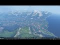
These fine, narrow terrain elevations were automatically generated based on data from Open Street Map. The user of the map can thereby recreate the original routes.
Kartografix  [author] 3 Mar @ 12:28am 
@GrinReaperHUN
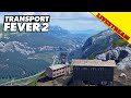
They are all in use. Natural Environment Professional and Alpine Climate are required for the textures. You can find the bridges and castles in different places on the map. The water textures are needed to represent the narrow rivers.
Kartografix  [author] 3 Mar @ 12:25am 
@dawidos85, @PR, @revenya
Please excuse the late reply. Have you been able to install the map in the meantime? In the instructions you will find information on how you can integrate the current version of Natural Environment Professional and where you can get this version.